
The Future of Ecological Intelligence

Salt Marsh Intelligence Infrastructure
for the Next Century.

ecoVision combines UAV imaging, transformer-based computer vision, and ecological modelling to automate species-level vegetation monitoring across vulnerable ecosystems, grounded in peer-reviewed research at Keele University.

Powered by
Keele University
AWS
ECOVISION — INFERENCE ENGINE v2.0
LIVE
S.mar
P.mar
S.mar
Mix
P.mar
S.mar
P.mar
S.mar
Mix
51.892°N 1.034°W
GSD: 2.1 cm/px
Alt: 30m AGL
Species Confidence
Spartina maritima96.0%
Puccinellia maritima93.0%
Mixed / Ecotone88.0%
Bare substrate97.0%
Water / Tidal99.0%
PIPELINE STATUS
Encoding tiles…
Segmenting…
Classifying blobs…
Scoring dominance…
DOMINANCE INDEX
0.68
tile_0024.png → SegFormer-B5 → mask_0024.pt_

The Global Problem

Ecological monitoring has not scaled with
environmental collapse.
01

Manual Surveys Can't Scale

  • Labour-intensive and expensive
  • Inconsistent methodology
  • Spatially limited coverage
  • Months to deliver results
02

Satellites Lack Precision

  • 10-30m resolution misses species
  • No temporal flexibility
  • No ecological granularity
  • Cloud interference limits coverage
03

Ecosystems Are Collapsing Faster

  • 30% global wetland loss since 1970
  • Pioneer zones shift in weeks
  • Monitoring lags biodiversity collapse
  • Decision-makers lack real-time data

The Platform

From drone imagery to
ecological intelligence.

A four-stage AI pipeline built for distinct ecological perception tasks.
01

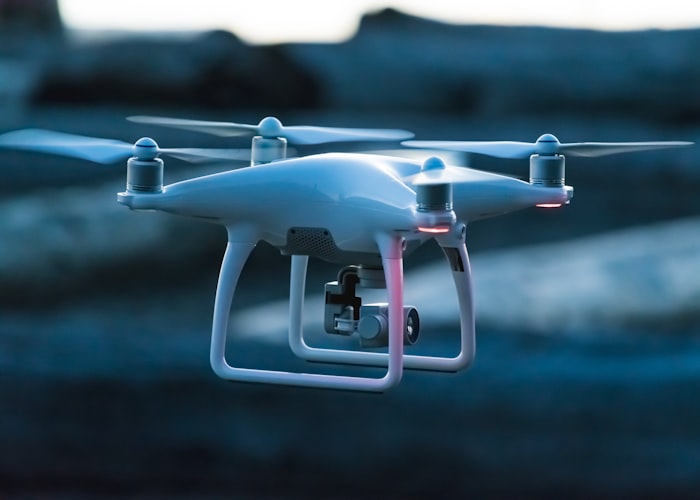
UAV Acquisition

DJI Phantom 4 Pro · 30m AGL · 2cm GSD

Systematic grid flights over intertidal survey zones. 80% overlap enables photogrammetric reconstruction and raw RGB orthomosaics at 2.1cm/px.

Specifications

Altitude
30m AGL
Resolution
2.1 cm/px
Overlap
80% fwd / 75% side
Format
GeoTIFF ortho

Research Foundation

Built on peer-reviewed
ecological and AI research.

EcoVision 2.0 is grounded in reproducible science, GIS workflows, and model validation.

96.2%
Pixel accuracy
99.0%
Species classification
0.941
Mean IoU
<8%
Dominance MAE

Transformer Vegetation Segmentation

Comparison content from the research script, preserved for later editorial selection.

UAV Species Intelligence

Comparison content from the research script, preserved for later editorial selection.

Dominance Mapping Framework

Comparison content from the research script, preserved for later editorial selection.

Ecological AI Infrastructure

Comparison content from the research script, preserved for later editorial selection.

Spatial Aggregation Systems

Comparison content from the research script, preserved for later editorial selection.

MAPIE Conformal Prediction

Comparison content from the research script, preserved for later editorial selection.

0%
Pixel Accuracy
SegFormer-B5
0%
Species Classification
ConvNeXt-Base
0%
Dominance Error (MAE)
Field-validated
0cm
Ground Sampling Distance
UAV imagery
0x
Survey Speed vs. Manual
Per hectare

Technology Stack

Institutional-grade
AI infrastructure.

Four architectural layers from edge delivery to research HPC.

Frontend Intelligence

  • Next.js · React
  • Cognito SSO
  • Presigned S3 Uploads
  • CloudFront CDN

AI Inference Layer

  • SegFormer-B5
  • ConvNeXt-Base
  • MAPIE Conformal
  • PyTorch · CUDA

Cloud Infrastructure

  • AWS ECS · Lambda
  • SQS · S3 buckets
  • EC2 GPU
  • CloudWatch

Research Compute

  • Keele HPC · SLURM
  • MLflow · DVC
  • VPN
  • TensorBoard

Roadmap

From saltmarsh monitoring to
ecological intelligence.

Active

British Saltmarsh

2024-25

Spartina maritima mapping
Foryd Bay validation
Dominance scoring v1

Developed in Partnership With

Keele University logo
AWS logo

Get Involved

Building the future of
ecological intelligence.

A new category of environmental infrastructure where AI, ecology, and scalable cloud systems converge.